Anisha has done MBA in Marketing from NMIMS And Executive Management(PMNO) from Harvard Business School. She has been instrumental in growing CATKing Digital with her experience with Marico and Henkel in the past.
Famous Lines and Frontiers
A common question that you will find in all GK sections of MBA exams is regarding the lines and frontiers between various countries all over the world. This is a very important topic and at least one question can be expected on this. Hence, all MBA students who are aiming to give exams with GK as a subsection are expected to know about all the boundary lines that India conducts with other countries.
What is a Line or Boundary?
An international line or boundary is a geographical boundary of political entities or legal jurisdiction between two countries. It defines two neighboring countries.
Here’s a list of such important boundaries or lines of countries:

| Sr. No. | Line/ Frontier | Location |
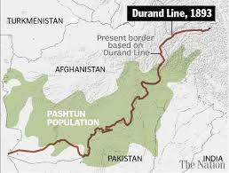
| 1 | Durand Line | Between Pakistan and Afghanistan |
| 2 | Hindenberg Line | Between Germany and Poland |
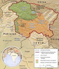
| 3 | Line of Control | Divides Kashmir Between India and Pakistan |
| 4 | Maginot Line | Between Germany and France |
| 5 | Mannerheim Line | Between Russia and Finland |
| 6 | McMahon Line | Between India and China |
| 7 | Oder Neisse Line | Between Germany and Poland |
| 8 | Radcliffe Line | Between India and Pakistan |
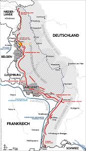
| 9 | Seigfried Line | Between Germany and France |
| 10 | 17th Parallel | Separated North and South Vietnam |

| Sr. No. | Line/ Frontier | Location |
| 11 | 24th Parallel | Between India and Pakistan |
| 12 | 26th Parallel South | Crosses through Africa, Australia, and South America |
| 13 | 30th Parallel North | Stands one-third of the way between the equator and the North Pole |
| 14 | 33rd Parallel North | Cuts through the Southern United States, Parts of North Africa, the Middle East, and China |
| 15 | 35th Parallel North | Between State of North Carolina, the State of Georgia, State of Tenessee, State of Alabama and State of Mississippi |
| 16 | 36th Parallel | The boundary of State of Missouri with the State of Arkansas |
| 17 | 36 degree 30’ Parallel North | Between Tenessee and the Commonwealth of Kentucky and between Missouri and Arkansas |
| 18 | 37th Parallel North | Boundary of Jefferson |
| 19 | 38th Parallel | Separates North Korea and South Korea |
| 20 | 39th Parallel North | Imaginary circle of latitude that is 39 degrees north of Earth’s Equatorial Plane |

| Sr. No. | Line/ Frontier | Location |
| 21 | 40th Parallel North | Boundary of Maryland |
| 22 | 41st Parallel North | Between State of Colorado and Nebraska and between State of Wyoming and Colorado and Utah |
| 23 | 42nd Parallel North | Border of New York- Pennsylvania |
| 24 | 43rd Parallel North | Between State of Nebraska and State of South Dakota, and the border of Jefferson |
| 25 | Parallel 44 degrees North | Imaginary circle of latitude that is 44 degrees north of the Earth’s equatorial plane |
| 26 | 45th Parallel North | Halfway point between the Equator and the North Pole |
| 27 | 45th Parallel | Between Montana and Wyoming |
| 28 | 49th Parallel | Between USA and Canada |
Important facts about these lines and frontiers:
- Durand Line was demarcated by Sir Mortimer Durand in the year 1896 between Pakistan and Afghanistan.
- Hindenberg Line is the line to which Germany retreated in the year 1917 during the First World War.
- Mannerheim Line was drawn by General Mannerheim.
- McMahon Line was demarcated by Sir Henry McMahon between India and China in the year 1914.
- Radcliffe Line was drawn by Sir Cyril Radcliffe in 1947 as a demarcation between India and Pakistan.
- 24th Parallel is a Line which Pakistan claims for demarcation between India and Pakistan. This, however, is not recognized by India.
All students are urged to go through this list and memorize these important lines and frontiers, and not lose out any opportunity of scoring in any question related to this topic.
Happy Learning!
Also Read:
Top Agricultural Producing Countries in the World
List of largest, biggest, longest : All Superlatives of India


Comments are disabled for now